It might be easy for some of us to move around using buses and subways, but it’s a whole different story for people with mobility needs. To make it easier for them, Google is rolling out a new feature to the popular mapping application, Google Maps. The feature, dubbed “wheelchair accessible” routes, is basically a tool that is meant to help people with mobility needs easily find routes that are wheelchair-friendly.
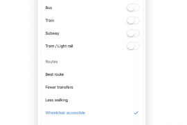
The new “wheelchair accessible” routes can be accessed by typing your desired destination into Maps and then tap on “Directions” (and select public transportation icon) and next on “Options”. Under the “Routes” section, you should see “wheelchair accessible” included in the route types.
Selecting this option will reveal a list of routes that have been constructed with people with disability in mind. You will be able to see information such as whether a transit station has easily accessible stops, entrances, and exits.

The new “wheelchair accessible” routes is now rolling out to Google Maps in metropolitan transit centers such as London, Tokyo, Mexico City, Boston, and Sydney. Google says the feature will be making its way to other transit agencies in the coming months.
“Wheelchair accessible” routes feature can also be very helpful to those on crutches or pushing a stroller. If you are in any of the mentioned cities, do let us know if the feature is showing up in Maps in your comments below.